Tye River Watershed Project
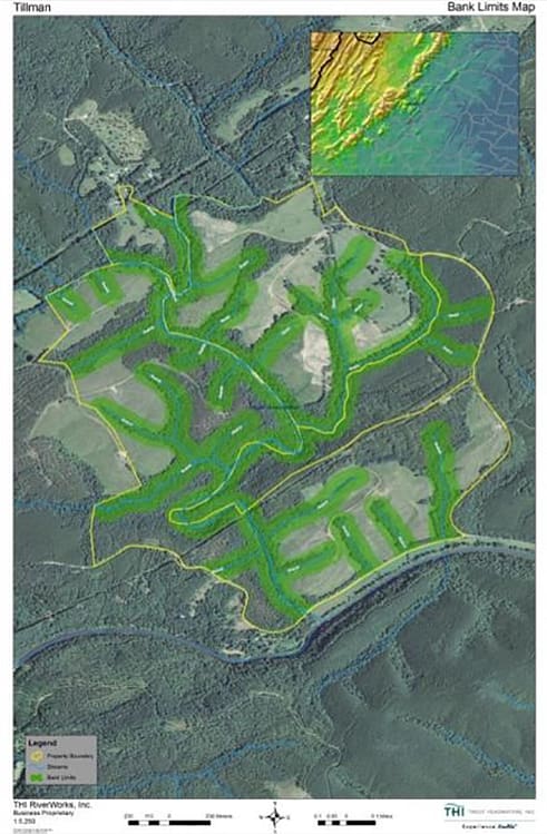
The Tye River project involves 440 acres, 6 miles of stream, and about 19,000,000 square feet restored buffer.
Where Is It Located?
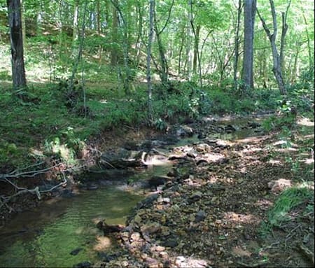
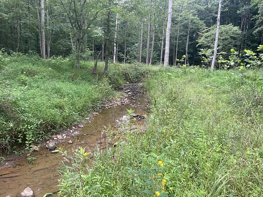
The Tye River is a tributary to the James River, which flows directly into the Chesapeake Bay at Hampton Roads, Virginia. The site is approximately 860 acres, located southeast of Arrington, VA. The property is privately owned and all onsite aquatic resources will be restored, enhanced and preserved. The site has been farmed for over the last century and possibly prior to that. The ecological condition of the streams and riparian buffers at the Tye River were originally degraded from these historic land use practices.
A Mitigation bank sponsored by Tillman Conservation, LLC., called The Tye River Mitigation Bank, was authorized by the Norfolk Corps District in Fredricksburg on April 21, 2020. The Bank area will be approximately 440 acres and is located along both sides of Rucker Run and its associated floodplains, and contains numerous unnamed tributaries to Rucker Run, including Pole Branch Creek. The Rucker Run is a large tributary to the Tye River downstream of the Bank site.
What is the purpose of the Mitigation Bank?
The purpose of the Bank is to provide environmentally responsible compensation for the loss of aquatic functions and services of stream and wetland resources through authorized impacts under Section 404 and 401 of the Clean Water Act, Section 10 of the Rivers and Harbor Act, and Section 62.1-44.15:20-23 of the Code of Virginia.
The Bank is designed to provide stream and wetland mitigation credits through the restoration, enhancement and preservation of aquatic ecosystems: streams, wetlands, riparian areas and upland buffers.
Tye River Mitigation Bank Tearsheet FREE DOWNLOAD
Geographic Service Area

Primary GSA Area = Blue Line / Secondary GSA Area = Green
The Primary Geographic Service Area (GSA) for the Bank is the Upper James 02080201 / Maury 02080202 / Middle James-Buffalo 02080203 / Rivanna 02080204 / Middle James-Willis 02080205 / Appomattox 02080207. The Secondary GSA is the immediately adjacent areas of the Lower James River 02080206 / Hampton Roads 02080208. Both areas are within the Commonwealth of Virginia and consistent with Section 62.1-44.15:53 of the Code of Virginia and in accordance with the Federal Banking Guidelines.
Work Done
Wetlands Borders
Riparian buffer areas along property streams and wetlands will be enhanced where lacking. The buffer areas will extend at least 100 to 200 feet from wetland borders and stream banks. Noxious weeds will be controlled in these areas to aid in the establishment of native vegetation. Livestock will also be prohibited from these areas through fencing to help maintain vegetation and stream health. Once established, these riparian buffers will help protect the property’s wetlands and streams by reducing the intensity of runoff and sedimentation from surrounding areas.
Streams and Banks
Streams that have been impacted by livestock and equipment crossings will be repaired. Degraded and trampled stream banks will be regraded to a more natural stable shape and replanted with suitable riparian/aquatic vegetation to stabilize the banks and discourage erosion. Failed culverts may be replaced with open channels. Native bottomland hardwood trees and shrubs will be added along stream banks to help provide shade for cover, habitat and water temperature control. In-stream structures like pools and riffles will be repaired, rebuilt, or added where necessary to replace natural stream functions and aid in natural sediment transport processes.
Roads and Trails
Any roads or trails established on the property will be crowned and the drainage carefully managed to avoid erosion and siltation of mitigation bank features. Where absent, water bars or swales will be added to steep slopes and roads to divert surface runoff and reduce water velocities. Runoff flows should also be controlled in swales though the use of native grass linings, check dams, and/or rock armoring. Road runoff should be directed to stilling basins and/or relatively flat, well vegetated areas away from aquatic resources.
Ground Work
Livestock and equipment will be kept away from these stream corridors and their associated buffers through proper fencing. Chemicals and fertilizers will not be used near these sensitive areas. Once established and properly maintained these streams and riparian areas will provide additional protection to the watershed by providing sediment/nutrient filtering and attenuation of peak runoff flows.
Site Details

Streams on the site
Pole Branch Creek is the main stream on the property, which is a tributary to the main channel of Rucker Run. The majority of the other streams on site are small intermittent and perennial streams.
Original Site Conditions
Original land use on the site is a mix of historic timber production, agricultural crops, grazing and home site development. The establishment of a conservation easement over the site will shift the land use away from agricultural and grazing and will continue to support the ecological resource functions that contribute to the site’s long term ecological viability.

Long-term Management Strategy
The Sponsor has retained Trout Headwaters, Inc. (THI) to oversee the mitigation project. THI has extensive experience as a full-service mitigation firm and has 20 years of experience with aquatic resource restoration, enhancement, and implementation, engineering and surveying, mitigation design, site selection, construction oversight, and monitoring.


